Land surveys are vital tools utilized by professional land surveyors to accurately measure and map various aspects of a property. These surveys serve distinct purposes, tailored to the specific requirements of different projects and scenarios. In this comprehensive guide, we will explore the different types of land surveys, shedding light on their unique characteristics and real-world applications.
We have been addressing 30 Most Common Questions Ask to Land Surveyors
This is Number 27.
What are the different types of land surveys?
Types of Land Surveys:We have covered Types of Land Surveys before but not necessarily in this context.
Example: When a homeowner plans to install a fence, they may request a boundary survey to ensure they do not encroach onto their neighbor's property and that their fence aligns with the legal boundaries.
Topographic Survey: A topographic survey focuses on capturing detailed information about the natural and man-made features of a specific area of land. Surveyors use elevation data to create contour lines, indicating changes in the land's terrain. Topographic surveys are vital for site planning, engineering projects, and environmental assessments.Example: Before constructing a new housing development, a topographic survey is conducted to identify slopes, drainage patterns, and potential building sites.
ALTA/NSPS Survey: The ALTA/NSPS survey is a comprehensive survey adhering to the standards set by the American Land Title Association (ALTA) and the National Society of Professional Surveyors (NSPS). It provides in-depth information about property boundaries, easements, encroachments, and other critical details required for commercial real estate transactions.Example: When a corporation purchases a large commercial property, an ALTA/NSPS survey is conducted to ensure all potential risks and encumbrances are disclosed, protecting their investment.
Subdivision Survey: A subdivision survey is performed when a large parcel of land is divided into smaller lots or parcels. The surveyor establishes new boundaries, identifies streets, and ensures compliance with local zoning and subdivision regulations.Example: When a developer plans to create a new residential neighborhood, a subdivision survey is essential to create individual lots and lay out the infrastructure.
Flood Elevation Survey: A flood elevation survey determines the elevation of a property relative to designated flood zones. This survey helps property owners assess flood risks and determine insurance requirements.Example: A homeowner in a flood-prone area may need a flood elevation survey to understand the potential impact of flooding on their property and obtain appropriate insurance coverage.
Construction Survey/Layout: Construction surveys, also known as layout surveys, involve setting up precise locations of structures, utilities, roads, and other elements on the construction site as per the construction plans. This ensures that the design is accurately implemented during construction.Example: During the construction of a new building, a construction survey is conducted to mark the positions of the foundation, walls, and utilities before construction begins.
Aerial Survey: Aerial surveys are conducted using drones or aircraft equipped with remote sensing technology to capture high-resolution images and data of large areas of land. These surveys are useful for mapping large territories, assessing vegetation health, and monitoring environmental changes.Example: A government agency may conduct an aerial survey to monitor forest cover and detect potential areas affected by wildfires or deforestation.
In summary, land surveys are fundamental instruments for a wide range of land-related endeavors, encompassing property transactions, real estate development, infrastructure planning, and environmental assessment. Each type of survey serves a specific function, providing essential data and insights for informed decision-making. Understanding the diversity of land surveys empowers property owners, developers, and professionals to select the most appropriate survey for their specific needs, guaranteeing precise and reliable results in land-related projects. By collaborating with licensed land surveyors and leveraging their expertise, individuals and organizations can ensure their projects are built on a solid foundation of accurate survey data, compliance with regulations, and preservation of property rights.
Learn all of the 30 most common questions asked to land surveyors by the general public, here:
30 Most Common Questions Ask to Land SurveyorsThe role of a quantity surveyor in the construction industry carries great importance for AEC firms and clients. The quantity surveying practice requires being in charge of calculating building material quantity and finances within required deadlines, which is a crucial responsibility. Taking the role of a cost consultant to generate a Bill of Quantities (BOQ’s) from 2D drawings can be tedious and error-ridden.
Adopting Building Information Modeling (BIM) technology helps quantity surveyors to boost efficiency and business through cost and time savings and improved coordination through accurate information exchange. Adding the most value at the preconstruction stage with parametric modeling enables the quantity surveyors to calculate accurate estimates, automate quantity surveying, speed up costing processes, and precisely capture and use project data.
Challenges faced due to traditional methods of quantity surveying
Traditional quantity surveying has always let down quantity surveyors with challenges that result in project delays due to cost and time overruns. Performing Quantity Takeoff based on 2D drawings for complex construction projects is high-risk.
Quantity surveyors working on fast-paced projects with traditional surveying processes can miss crucial details leading to:
Uninformed decision-making in the preconstruction stage Costly rework due to errors in multiple 2D drawings Material waste and costing errors due to missing elements of double counting Inaccurate logistics planning Errors in data movement within files Variations in material quantity and cost during the design phase Revision of BOQ’s to accommodate design variations Loss of tenders or bids due to inaccurate and incomplete quantity surveyingHow BIM affects quantity surveyors
Estimations performed by quantity surveyors have become straightforward with BIM-based cost estimating in comparison to paper drawings.
The potential uses of BIM in modern-day QS practices include:
Preparation and extraction of accurate Quantity Takeoff’s from 3D models Generating precise cost estimates and reports based on components and stakeholder relevancy Early clash analysis during the coordination process Preparation of BOM’s Streamlined bidding and tendering processes based on client compliance and bidding offers Financial comparative analysis and value management Better sustainability based on formulated financial calculations Accurate feasibility studies for greater cost reliability and maximum value Promote procurement processes based on informed decisions through digitized building information Improved material waste management through model-based simulationsWithin the traditional role, the responsibilities of a quantity surveyor were limited to a narrow scope, whereas the modern quantity surveyor needs to do more. From investment appraisals to construction project management, and life cycle costing to value engineering, quantity surveyors need to undertake a broad spectrum work profile, and evolve as professional experts.
Benefits of BIM for quantity surveyors
Precise model validations to incorporate evolving changes in the design phaseThe key competency of BIM for quantity surveyors is the ability to validate model information. Parametric modeling assists quantity surveyors with auto-adjustment of costs based on evolving project data in a Common Data Environment (CDE). Identifying quantities at specific stages or levels through model manipulation helps extract useable measures and quantities.
Informed decision-making leading to greater productivity and cost savings
Automating core processes enables quantity surveyors to latch on to informed decision-making whilst working on a live model. The productivity factors can be enhanced through 5D BIM, wherein evolving changes can be factored in to keep quantity surveyors updated. This reduces preconstruction communication fragmentation, lowers information conflicts, and mitigates rework leading to project cost savings and reduced project delays.
Accurate BOQs nullify logistical errors and reduce building material wastage
Accurate and detailed project simulations through 4D BIM can assist quantity surveyors to visualize and plug logistical gaps. As Bill of Quantities is an important tool to generate accurate cost management, BIM provides 5D as a means to automatically produce BOQ’s. BIM can extract quantities and calculate costs at any time during the design stage; and mitigates material waste. Comprehensive knowledge of cost determinants based on the BIM design engine helps churn out accurate and reliable cost estimates.
Improved bid management with detailed models and drawings
BIM application delivers intensive and detailed deliverables like 3D models and drawings compared to their traditional counterparts. Wrong assumptions based on 2D drawings can lead to bidding losses, whereas the preparation of comprehensive and straightforward construction data diminishes coordination and data gaps amongst various project trades. With the knowledge and skill of extracting accurate quantities from the building model, bidders can put forth winning or competitive bids.
A project management solutions firm from Saudi Arabia needed a coordinated 3D BIM model at LOD 500 for a healthcare facility to achieve better scheduling and ROI. Based on 2D drawings, the project team at Hitech CADD Services generated a clash-free 3D BIM model with accurate material takeoffs.
Onsite risk and rework were mitigated by resolving any trade interferences in the 3D model, and deadlines were met through quick collaboration to streamline tasks, save time, and reduce rework. The 3D model also helped the client achieve higher ROI based on clear and precise scheduling.
Future of quantity surveying with Big Data, AI, and Machine Learning
Enhancing project performance and producing better construction project outcomes through improved overall productivity is key for quantity surveyors. Quantity surveyors have become more mindful of transformational benefits and improvements in quantity measurements through advanced estimating tools. The reinforcement of BIM with Big Data, AI, and Machine Learning will lead to a significant reduction in workloads helping clients to reach maximum value.
Big Data
Big Data has made QS more realistic through accurate cost data. It integrates a wide range of cost data to generate accurate cost estimates. A series of algorithms, data mining, neural networks, and more are required skills that a modern quantity surveyor needs to acquire.
Artificial Intelligence
Artificial Intelligence or AI can process large amounts of historic data and past experiences to prepare an initial cost estimate. Neural networks and regression testing or models help improve the estimation accuracy and enhance the alternative design and material selection.
It has been observed that the accuracy of construction cost at the feasibility stage is within 25% to 30%, and it reduces to less than 20% as the design evolves, and as estimators provide their input. Design decisions can be more realistic, and projects can become more effective, improving the overall construction process.
Machine Learning
Machine Learning can help quantity surveyors reduce time and cost overruns for an ongoing project. Extracting potential issues that cause these overruns can help profit maximization for contractors, clients, etc.
Conclusion
The ever-evolving role of a quantity surveyor has led to new services that include value and risk management, FM, sustainability, financing, administration, and more. Furthermore, the maturity of BIM has made it imperative for quantity surveyors to adopt new processes and software-driven technology to generate accurate deliverables at the first instant.
The potential impact of software-driven technologies that are supplemental to BIM will continue to enhance the quantity surveying process. Quantity surveyors will take on a versatile and broad-spectrum profession as they continue to become more effective and productive with BIM.
In surveying, accurate measurements and precise calculations are paramount in obtaining reliable results. However, simply obtaining results is only half the battle. It is equally important to estimate the accuracy of the results obtained. The accuracy depends on various factors such as errors in measurement techniques, round-off errors, and even mistakes that could occur during calculations. In this discussion, we will focus on calculation errors and how to minimize their effects.
Calculation errors can occur in many different ways, including inaccurate calculators or computers, round-off errors due to expressing intermediate values to a finite number of significant figures, errors in the calculation model, and mistakes. These errors can lead to incorrect answers and must be avoided by considering all sources of error and taking appropriate action to minimize their effects.
You must consider all sources of error in your calculations and take appropriate action to minimise
their effects. Calculation errors can occur in a number of ways:
accurate so sometimes the answers are wrong!
- Round-off errors because intermediate values are expressed to
a finite number of significant figures.
- Errors in the calculation model, e.g. using equations that are only
approximately correct.
- Mistakes.
Even when no apparent errors occur, the finite number of significant figures that calculators and computers can handle can still result in incorrect answers. For instance, taking the square of the square root of 2 should result in 0, but some calculators may display 1 x 10 -9 as an answer. Another example is when the cosine of 1” is taken and then the inverse cosine function. Ideally, the answer should be 1”, but the actual result may differ. Also, round-off errors can accumulate over a series of calculations, leading to significant inaccuracies.
It is vital to note that while computing machines can handle very small numbers, they can only carry a specific number of significant figures. Thus, a calculator or computer may not distinguish between two seemingly similar numbers. As such, it is crucial to use techniques to avoid calculation-induced errors as much as possible.
One technique is to thoroughly check calculations and results for mistakes. Also, using modified methods, such as converting 23° 46' 53.1234" to decimal degrees, can save space in a calculator display, thus avoiding the machine precision problem. We will discuss the accuracy of trigonometric functions in machines later.
Checking Your Calculations
In order to ensure accuracy in surveying calculations, it is crucial to perform thorough checks. Merely verifying the original calculation step by step is not sufficient, as there is a risk of blindly accepting incorrect figures. There are several methods for carrying out effective checks, including obtaining an independent calculation from another person, performing a second calculation using a different mathematical process, reversing the calculation, and utilizing built-in checks. It is also important to check data input, estimate the likely magnitude of the answer prior to the calculation, and use test data from textbooks to ensure that equations and steps are being followed correctly. Common sources of errors include illegible figures, untidy arrangements, transcription errors, and typographical errors. Additionally, it is essential to ensure that the data is correct and to design measurement techniques to minimize or locate any mistakes. One useful method is to make an estimate of the likely magnitude of the answer before doing the calculations. If using a program, it is important to check the program itself and to compare the results with those from a program independently written by someone else. It is inevitable that mistakes will occur, but good surveyors find and correct them before reporting results to their employer or client.
Here are the steps for checking calculations:
Get an independent calculation by another person and compare the results of the calculations. This involves having someone else perform the same calculation using the same data and comparing the results for any discrepancies. This helps to ensure that the original calculation was accurate and can identify any mistakes made by the first person. Do a second calculation but use a different mathematical process. This involves performing a second calculation using a different method or equation than the original calculation to ensure that the result is the same. This eliminates the possibility of repeating the same mistake from the original calculation. Reverse the calculation. This involves using the results of the calculation to calculate the input data. For example, if you converted data from feet to meters, you can reverse the calculation by converting the result back to feet to check that it matches the original input. Check for built-in checks. Some survey problems have built-in checks, such as the angles in a triangle adding up to 180 degrees. These can be used to verify the accuracy of the calculation. Check data entry. Verify that the data was correctly entered by having the computer "echo" or display what was inputted. Estimate the answer. Before performing the calculation, make an estimate of the likely magnitude of the answer. Then, after completing the calculation, compare the result to the original estimate to check for accuracy. Use test data. Use test data from textbooks or generate simple data to check the calculation. Identify potential sources of error. Check for potential sources of error, such as illegible figures, untidy arrangements, unsystematic work, trying to do too many steps at once, transcription errors, and typographical errors. Ensure correct data and measurement techniques. Ensure that the data is correct and the measurement techniques are designed to avoid, minimize or locate any mistakes.By following these steps, you can verify the accuracy of your calculations and identify any errors before reporting your results.
At the end of the day, obtaining accurate surveying results requires more than just measurements and calculations. The accuracy of the results obtained must also be estimated, and all sources of error must be considered and minimized. By doing so and using appropriate techniques, surveyors can obtain reliable and accurate results.
Double rodding is a technique used in land surveying to ensure the accuracy of measurements taken with a leveling instrument, such as a level or transit. The process involves using two rods, one placed in the location where the measurement is being taken and another at a predetermined distance away.
Here is the step-by-step process for double rodding:
Set up the leveling instrument: The leveling instrument is set up at a suitable location, such as a tripod, and adjusted to be level.
Place the first rod: A surveyor places the first rod at the point where the measurement is being taken. The rod is set vertically and the surveyor reads the measurement off the rod using the leveling instrument.
Place the second rod: The surveyor places the second rod at a distance away from the first rod. The distance is typically set based on the distance that can be accurately measured with the leveling instrument.
Take the second reading: The surveyor then reads the second rod using the leveling instrument. This measurement provides a check on the accuracy of the first measurement.
Repeat the process: The surveyor may repeat this process several times to ensure the accuracy of the measurements. This is especially important when working on long distances or in challenging terrain.
Double rodding is a useful technique for ensuring the accuracy of measurements taken with a leveling instrument. It provides a way to check the measurements and ensure that they are consistent and accurate.
I get the same question a lot. "Why can't I just survey my land with my phone? It has GPS in it." The truth is while smartphones are convenient and useful for many tasks, they are not suitable for professional land surveying. To ensure accurate and reliable results, it is important to use specialized equipment and software designed for accuracy and precision, and to follow established standards and procedures. There are several reasons for this:
Limited GPS accuracy: The GPS in a smartphone is generally accurate to within a few meters, which is not sufficient for precise land surveying. Professional land surveying equipment, such as survey-grade GPS receivers, can provide accuracy to within a few centimeters.
Interference and signal loss: GPS signals can be affected by various factors, such as atmospheric conditions, nearby buildings or trees, and even the user's body. This can result in signal loss or interference, which can significantly affect the accuracy of the measurements.
Inadequate data recording: While smartphones can record GPS coordinates, they lack the advanced data recording and management features required for professional land surveying. Surveyors use specialized software and equipment to record and manage complex data sets, and to perform calculations and analysis.
Legal requirements: In many jurisdictions, land surveys are subject to legal requirements and standards that must be met for the survey to be recognized and accepted. Using a smartphone to survey land may not meet these requirements, which could lead to legal and financial consequences.
How accurate are land survey measurements?Land survey measurements can be highly accurate, depending on the techniques and tools used in the surveying process. The accuracy of land survey measurements is usually measured in terms of the precision and accuracy of the measurements taken.
Precision refers to the consistency of the measurements, while accuracy refers to how closely the measurements match the true values. A high level of precision means that the measurements are very similar to each other, even if they may not be exactly accurate. On the other hand, high accuracy means that the measurements are very close to the true values.
Different types of land surveys may require different levels of accuracy. For example, a boundary survey may require higher accuracy than a topographic survey. The accuracy of land survey measurements can also be affected by various factors, such as weather conditions, the terrain, and the quality of the surveying equipment.
To ensure the highest level of accuracy, professional land surveyors follow established standards and procedures, and use advanced equipment such as GPS and laser technology. They also undergo extensive training and education to develop the necessary skills and knowledge to conduct accurate land surveys.
What is the difference between Accuracy and Precision in land surveying?Accuracy and precision are two important concepts in land surveying that refer to different aspects of measurement.
Accuracy refers to how closely a measured value corresponds to the true or actual value of a particular feature or point on the earth's surface. In other words, it is the degree of conformity between the measured value and the actual value. Accuracy is important in land surveying because it ensures that the data collected is reliable and useful for decision-making processes.
Precision, on the other hand, refers to the level of consistency and reproducibility of the measurements. It is the degree to which repeated measurements of the same feature or point on the earth's surface produce the same result. Precision is important in land surveying because it ensures that the data collected is consistent and can be relied upon for comparison and analysis. To put it simply, accuracy is about how close a measurement is to the true value, while precision is about how close multiple measurements are to each other.
In land surveying, both accuracy and precision are critical for producing reliable data. High accuracy ensures that the measurements are as close to the true value as possible, while high precision ensures that the measurements are consistent and reproducible.
We have a brand new way to both Find available Land Surveying Jobs anywhere in the world as well as post open positions that you are aware of. We are calling this action packed new Jobs Resource for Land Surveyors, the Surveyor Jobs Megaboard. Here is how it works:
For Quick Access, try this: Check out the New Surveyor Jobs MegaBoard!This is the Surveying Jobs Board, which has been hosted by Land Surveyors United Community since 2011. You can also find the jobs inside the board aggregated to the Jobs page on Land Surveyors United Community.
| AK AL AR AZ CA CO CT DE FL GA HI IA ID |
IL IN KS KY LA MA MD ME MI MN MO MS MT |
NC ND NE NH NJ NM NV NY OH OK OR PA RI |
SC SD TN TX UT VA VT WA WI WV WY |
How to access the Mega Jobs Board from the old Jobs Page.
As a global community of Land Surveyors, it is our responsibility to collectively educate the public regarding the importance of Land Surveyors to society. This article answers just one of the most common questions asked by the public to Land Surveyors. Let's jump in.
#28: Can land surveyors help with construction layout?
This is number 28 of the most common questions asked to Land Surveyors by the general public. Visit this post for all 30 questions.
30 Most Common Questions Ask to Land SurveyorsDiscover the indispensable contribution of land surveyors in construction layout, where precision and accuracy are paramount. This article explores the vital role of land surveyors in construction projects, shedding light on their expertise in ensuring accurate placement and alignment of structures. As you delve into this topic, we invite you to refer to our comprehensive guide, "Unveiling the 30 Most Common Questions Posed to Land Surveyors," which covers a wide range of inquiries related to the field. Additionally, gain a deeper understanding of the profession's significance in land development projects by exploring our post titled "The Crucial Role of Land Surveyors in Land Development Projects." We also encourage community members to share their local perspectives on each of the 30 common questions, fostering a diverse and engaging discussion within our global community.
Unraveling the Importance of Land Surveyors in Construction Layout:
Unlocking the secrets behind successful construction layout, land surveyors emerge as instrumental figures collaborating closely with architects, engineers, and contractors. Their expert guidance and meticulous attention to detail guarantee precise implementation of design plans, aligning every element to perfection.Working closely with these professionals, land surveyors bring their extensive training, advanced equipment, and meticulous attention to detail to ensure that design plans are executed with unparalleled precision, resulting in the flawless alignment of every element within the construction project.
Land surveyors act as the bridge between the design and construction phases, translating the vision of architects and engineers into tangible and accurate on-site realities. They possess a deep understanding of the nuances involved in turning two-dimensional plans into three-dimensional structures. Through their comprehensive grasp of surveying principles, land surveyors are able to navigate the intricacies of site-specific conditions, enabling them to determine optimal positioning and alignment of structures.
Collaborating closely with architects, land surveyors provide valuable insights during the initial planning stages. They bring their knowledge of site topography, including elevation changes, natural features, and potential obstacles, to the table. By combining this information with the design plans, they contribute to informed decision-making regarding site suitability and layout feasibility. This collaboration ensures that the construction project is tailored to the unique characteristics of the land, maximizing its potential while addressing any challenges that may arise.
During the construction process, land surveyors become the custodians of accuracy and precision. Armed with advanced surveying equipment, such as total stations, GPS receivers, and laser scanners, they meticulously establish control points on the site. These control points serve as reference markers for positioning critical components like foundations, walls, columns, and utilities. By precisely marking these points, land surveyors ensure that construction teams have a reliable guide for implementing the design plans flawlessly, minimizing errors, and maintaining strict adherence to specifications.
Moreover, land surveyorsplay a vital role in quality control throughout the construction phase. They diligently monitor the work in progress, cross-referencing it against the design plans to identify any deviations or discrepancies. Their keen eye for detail allows them to catch and rectify potential issues before they escalate, ensuring that the construction proceeds according to the intended specifications. By conducting regular checks and verifications, land surveyors act as guardians of quality, promoting the highest standards in construction layout.
Interpreting Design Plans with Unrivaled Expertise:
Land surveyors excel in interpreting architectural and engineering design plans, effectively translating them into practical instructions for construction teams. Through careful analysis, these professionals gain a comprehensive understanding of the layout, dimensions, and positional requirements of structures within the project site.
Establishing Control Points with Utmost Precision:
A primary responsibility of land surveyors in construction layout involves establishing control points throughout the site. These meticulously placed markers serve as reference points, enabling accurate location determination for critical components such as foundations, walls, columns, and utilities. Leveraging cutting-edge surveying equipment and techniques, surveyors expertly mark control points, ensuring seamless alignment with the design plans.
Verification and Quality Control: Ensuring Flawless Execution:
Land surveyors maintain an unwavering commitment to verifying the placement and alignment of structures throughout the construction process. Their meticulous checks of dimensions, levels, and positions against approved plans guarantee compliance with regulations, design specifications, and stringent safety standards. By performing ongoing verification, surveyors swiftly identify and rectify any discrepancies or deviations that may arise during construction, ensuring flawless execution.
Monitoring Earthwork and Grading: Creating a Solid Foundation:
Land surveyors also play a critical role in earthwork and grading activities during construction. Through detailed assessments of existing terrain, elevation, and contours, these professionals provide essential guidance to contractors regarding proper excavation, filling, and grading. By accurately accounting for the site's topography, surveyors establish a robust foundation for the construction process.
As-Built Documentation: Ensuring Accurate Record-Keeping:
Upon completion of a construction project, land surveyors conduct meticulous as-built surveys, documenting the final positions, dimensions, and layout of the structures. These surveys serve as a crucial reference for future maintenance, renovations, or expansions. By capturing the as-built conditions with unparalleled accuracy, surveyors provide essential records that facilitate ongoing asset management and guarantee the precision of property records.
So, can land surveyors help with construction layout?
In the realm of construction layout, land surveyors play an indispensable role in ensuring flawless execution, precise alignment, and regulatory compliance. Their expertise in interpreting plans, establishing control points, verifying construction progress, and meticulously documenting as-built conditions is paramount for achieving impeccable and compliant construction outcomes. As you delve deeper into this subject, we encourage you to explore our comprehensive guide, "Unveiling the 30 Most Common Questions Posed to Land Surveyors," for a broader understanding of the multifaceted field of land surveying. Gain further insights into the professional status and wider contributions of land surveyors by exploring our informative post titled "The Crucial Role of Land Surveyors in Land Development Projects." We warmly invite community members to contribute their local perspectives on each of the 30 common questions, fostering an engaging and diverse discussion that enriches our collective understanding of land surveying practices. Expand your knowledge, empower your decision-making, and uncover the crucial role of land surveyors in construction layout through our comprehensive resources.
We invite community members to contribute their local perspectives on each of the 30 common questions, fostering an engaging and diverse discussion that enriches our collective understanding of land surveying practices.
I have been using VRS for project location for some years. I need to set up a control network for the Highway Department using a static network. I dug out the old Ashstech Extremes to set up the network. When I downloaded the files, both the almanac and datasets were dated 02.107 instead of 21.333. I was always under the impression that the receivers got their time stamp from the GPS signals.
When I dump them in a project, they appear reasonable relative to each other. None were on a known point, and the crew didn't VRS any because I was going to send them to OPUS before I solved the net. OPUS rejected them because they were 50 km outside the nearest polygon. I am surrounded bu CORS sites. I thought it might be a labeling error and tried just changing the date tags, but that didn't work. I have done a lot of searching for a common occurance or explanation, but found nothing out there. There is no documentation in my Ashtech literature suggesting an internal clock.
Any Ideas out there?
Thanks
Construction companies play a significant role in the infrastructural development of a city or a country, thus improving the quality of the lives of people staying there. The companies that perform construction work employ engineers, designers, and contractors who work together to resolve complex challenges associated with the projects that they are working on. Therefore, they must have proper consultation services whenever they need to deal with different challenges in the workplace. Construction consultancy is a booming industry these days as construction companies often need help dealing with the various complexities of the work that they are carrying out.
The experts that offer consultancy solutions to the clients can look through the critical aspects of a job and provide top-grade expertise that can be very good for the construction work.
As the owner of a significant construction business, you will always need to have your contractors on board when trying to take some crucial decisions relating to your work. You will also have to ensure that your supply chain is managed efficiently so that you can get everything you are looking for when you need to do so. With the help of a consultant quantity surveyor, you can see to it that you are well-equipped to handle the pressures of your work and finish projects in a way that suits the needs of the clients you are serving. The construction works should be planned and coordinated so that optimum efficiency is ensured at every step of the way. When you have the support of commercial construction consultants with many years of experience in this industry, you can easily make vital decisions relating to your work that can be advantageous for you in more ways than one.
To handle the strategic aspects of the construction project you are working on; you need to get the help of a professional that can manage the logistical and deigning aspects of the construction work. You will also need someone who can collaborate with the engineers, the architects, and the ground planners who need to come up with ways to resolve major and minor challenges in the workplace. Professionals who have undergone commercial construction training before getting into this industry can help maintain ease of communication between the various individuals working on the project. They can help you develop a competent management strategy for boosting the efficacy of the construction work you and your team handle on a day-to-day basis.
One of the persistent problems that construction companies often have to deal with is disputes between multiple professionals when they disagree on something. Disputes often happen because people may have differing opinions and notions about how a project needs to be handled. In such cases, it is important to have dispute management methods that can help you ensure better proficiency in the construction process at every step of the way. Construction consultants know how to handle construction disputes so that they do not become a source of botheration for the people working on the construction tasks. This is why, you must have their expertise as it can help you to resolve the problems with your construction project at the earliest opportunity.
Construction dispute resolution requires in-depth and sound knowledge of the process of construction and this is why it is a good idea to have the best consultants who would be working with you in your project. Experience matters in this field of work. When you have the construction contract advice that these consultants have to offer, you can deal with all kinds of unforeseen challenges you may not have thought about. It can help you to allocate your resources in a way that would be beneficial for the construction task you are working on.
Proper management of the resources is also vital when you are trying to improve the output of your construction project. The construction consultants go through NEC training and this makes it possible for them to come up with robust techniques for solving challenges critical for the operations handled within the construction project. So, when you get a competitive team of construction consultants to help you manage the budget and resources of your project, you can also ensure better results for your tasks once they are finished.
Getting the services and expertise of a commercial construction consultant is easy these days, as many companies cater to the growing needs of the construction world. It means you can get a team of consultants to work on your project and ensure its efficiency on multiple levels. You can also reduce waste and make use of all the materials in a precise manner. So, make sure you search for a skilled team of consultants who would be glad to offer you the support you need.
For All Land Surveyors - Best of Both Worlds
Prism Education App: http://go.srvyr.com/prism
This app not only aggregates the shared advice and questions from the other 2 apps, it is packed with surveying basics, surveying articles, resources, live events and more. Add this app to your phone to see content shared from both the New Surveyor App and the Old Surveyor App.
Learn More: https://landsurveyorsunited.com/.../help-the-community...
-----------------------
This app was developed by Justin Farrow on behalf of the Land Surveyors United Community. If you would like to help improve the app, consider making a donation to help with upgrade and help us help more surveyors around the world.
https://landsurveyorsunited.com/donate
Global Surveyors App
https://globalsurveyors.glideapp.io/
International Surveying Hubs and Forums
by Land Surveyors United
Land Surveyors United Members UNITE! Find your country and either introduce yourself or tell us something about surveying in your area of the world! http://landsurveyorsunited.com
------------------------
This app was developed by Justin Farrow on behalf of the Land Surveyors United Community. If you would like to help improve the app, consider making a donation to help with upgrade and help us help more surveyors around the world.
https://landsurveyorsunited.com/donate
Surveying Jobs App
https://surveyingjobs.glideapp.io
This app is for those who are new to Land Surveying (aka Young Surveyors) to learn all of the basics of land surveying with the help of seasoned surveyors. In this app, not only can you read advice shared by Seasoned Surveyors, you can also ask for advice without asking your own crew members. In other words, you can silently study up on what is expected of you in the field.
Find Land Surveying Jobs Anywhere in the world inside this app built for http://landsurveyorsunited.com/jobs by Land Surveyors United Community
------------------------
This app was developed by Justin Farrow on behalf of the Land Surveyors United Community. If you would like to help improve the app, consider making a donation to help with upgrade and help us help more surveyors around the world.
https://landsurveyorsunited.com/donate
Land Survey Equipment Support App
https://equipmentsupport.glideapp.io/
by Land Surveyors United
Find help with your Land Surveying Equipment from the field with quick links to forums, share photos and videos inside Land Surveyors United Community
------------------------
This app was developed by Justin Farrow on behalf of the Land Surveyors United Community. If you would like to help improve the app, consider making a donation to help with upgrade and help us help more surveyors around the world.
https://landsurveyorsunited.com/donate
Land Surveyor Dictionary App
https://surveyordictionary.glideapp.io/
Carry a mobile Land Surveying Dictionary and Land Measurement Conversion Guide with you for quick reference. Brought to you by Land Surveyors United Community https://landsurveyorsunited.com
------------------------
This app was developed by Justin Farrow on behalf of the Land Surveyors United Community. If you would like to help improve the app, consider making a donation to help with upgrade and help us help more surveyors around the world.
https://landsurveyorsunited.com/donate
For the Seasoned Surveyor
Seasoned Surveyor App https://go.srvyr.com/seasonedsurveyor
Imagine a world where you only had to say something once. Imagine the removal of frustrations involved with teaching the greenhorn the basics. If you were to add your expectations and advice to the app and then just ask the new surveyors to add the app to thier phone, they will have all of your instructions and knowledge on that phone they have a hard time putting down.
Learn More: https://landsurveyorsunited.com/.../help-the-community...
-----------------------
This app was developed by Justin Farrow on behalf of the Land Surveyors United Community. If you would like to help improve the app, consider making a donation to help with upgrade and help us help more surveyors around the world.
https://landsurveyorsunited.com/donate
For Those New to Surveying
New Surveyor App: https://go.srvyr.com/newsurveyor
It is no secret that the boss doesn't understand you. You are most likely from a different generation and/or may have a different style of learning. One thing is for certain - you do not know what you are doing and that is ok. But imagine being able to save yourself the embarrassment of asking a surveying veteran a simple question about something which you are already expected to know. By asking for advice inside the New Surveyor App, you are asking ALL of the experienced surveyors in the community and crowdsourcing the answers. Not only that, you'll have the advice and expectations shared by your Party Chief so everyone is on the same page.
Learn More: https://landsurveyorsunited.com/.../help-the-community...
-----------------------
This app was developed by Justin Farrow on behalf of the Land Surveyors United Community. If you would like to help improve the app, consider making a donation to help with upgrade and help us help more surveyors around the world.
https://landsurveyorsunited.com/donate
What is this?
Latest Available Land Surveying Jobs North America, South America, Oceania, Middle East
Land Surveying Jobs By Type
Good morning every body,
I have an issue in geomensura with a survey i made. When i import the dots in the sofware, everything is mirror intverted. Any solution to switch the dots uin the right place?
Thanks in advance, S.bruant.

I'm looking for information on how to get into the surveying field.......where does one begin?
With Remote ID going into effect on September 16th, it has never been more important to conduct public drone operations responsibly. Part 107 pilots must understand the do's and don'ts of operating drones in public.
Aerotas's newest blog post will help you and your business:
understand the regulatory landscape overseeing aerial surveyingavoid costly pitfalls while conducting drone ops in publicbuild a relationship with the communities in which you operateGive it a read at the link below and let me know what you think!
Link to Blog: https://www.aerotas.com/blog/commercial-drone-operations-in-the-public
What will be the most important fo a Licensed surveyor
we had a problems with academically qualifid people who don't have professional qualification
according to Survey act of Sri Lanka only Licensed surveyors are alowed to do private practice
as it now government surveyors engaged under the surveyor general illegally practice the profession which could be stopped under civil law ,
our survey council will not take action ,as normal laymen will not come forward to go against this type of mal practices and will not report to the council,
only problem here is the illegally surveyed plans signed by Licensed surveyors who support mal prctice
😀that is our professional greediness
I need to know from surveyors around the world how you tackle this type of thing
I've got the old Sokkia NET2 Monmos (new Topcon MS1AXII) to hook up to a RS232 port.
Does anyone have a cable (DOC210) or a connector or the description of the female hirose connector that fits underneath?
All info is highly appreciated.
Thanks,
Arjen
The distance of the closing course of plat S-142 (Search Official Records - Phil Diamond - Orange County Comptroller (occompt.com)), which is 900.48', is not the sum of the individual courses. I get a sum of 786.88'. What do you get?
Hi everyone,
I'm Ziyad and I'm reletively new to land surveying. I've interned at a company in New Mexico that went bankrupt and was helping the chief land surveyor then. I since moved to Wyoming and now I'm trying to figure out how to get back into the profession. I'm currently going to school for it though I'm unsure about the non ABET accredited degrees that are land surveying related.
I had a question about LSIT in Wyoming. Is it necessary? I see many land surveryor jobs come up that require it, though when I google it I only really get results for LSAT, which is a Law related exam. If this is necessary, how do you go about getting one?
Thanks,
Ziyad J
Hi
I'm new to the site so hope I'm on the right forum for this type of question.
I'm working on a legal case and wonder if anyone can help. During a Limited Special Review in 1970 in England the parish council trying to get the status of a way changed from a Rupp to a Boat filled out a standard questionnaire. On this questionnaire they stated that the recorded definitive width of a way has been incorrectly recorded on the original map and statement as an average of 4 feet and should have been recorded as a minimum of 6 feet. The County Surveyor then went out and reported that the Rupp in question was suitable for re classification to a Boat. The definitive map and statement were changed to show this as a Boat however the width was not altered and to this day shows a stated width of an average of 4 feet. The Byway has boundary features along its entire length and at its narrowest is at least 6 feet (probably closer to 7 feet ). At its widest its about 16 feet. In the opinion of any Surveyors here who are familiar with this review should the width also have been changed on the definitive statement at this time to show the correct width in line with the Parish Councils comments. Also were surveyors at this time issued guidance as to what the minimum width should have been for a Boat under this review . Any knowledge would be extremely helpful and if any members can point me towards the guidance from this time or even show it that would be extremely helpfull.
obstructions have been placed outside of a property boundary wall that now narrows the byway to about 9 feet from12 feet. The council are saying this can't be an obstruction as there is over 4 feet of room still available and that any attempt to have the obstructions removed would be defended as a " Serious dispute " and give the magistrates court no option but to not enforce an order for removal. I'm arguing that had the map been updated as is the statutory duty of the council. A minimum of 6 feet would of course include a width of 12 feet.
Thank you in anticipation.
I have been trying to find the service manuals for the Sokkia SeT5f and the set5-30r total stations and I could not find them. Can anyone help me.
I would like to know if there is a book on the mathematics of cloud point algrithms generation for doing a subroutine for a computer program that I am making ?.
Thanks in advance for your help.
Jesus F. Pacheco.
Wow... Another 300+ Surveyors have joined the community since the last milestone, putting us at over 16,900+ members worldwide on Land Surveyors United!!!
We also crossed 37,000 members inside our Private Group https://facebook.com/group/landsurveyors
Land Surveyors United Community is now 18,000+ Land Surveyors Strong
Help us get to 19k by joining us today on https://landsurveyorsunited.com/community
Those of you who have taken the leap from Facebook and joined our Personal Development Community for Land Surveyors, we thank you! Our land surveyor community reached a new milestone yesterday - we accepted our 16,900th member and counting. Do you realize how incredibly rare that is? ...the most rare and we thank you for being a part of it. We will definitely cross 17k members before the end of the summer!
For those who have made the small leap to our official community at https://landsurveyorsunited.com/hubs we thank you. Because of you Land Surveying will NEVER DIE! It will never be replaced either. Many aspects of land surveying can never be automated without sacrifice to precision and passion. My dad's passion for helping surveyors extends beyond the grave and continuously inspires me to lift this community up, bring the members together and help them to help themselves and one another. Never influenced by advertising dollars , we are here to help each other become better surveyors and provide breadcrumbs for future surveyors to follow..
Although many continue to flock to Facebook Groups and Instagram for a quick fix, Land Surveyors United Community continues to grow. Many are starting to realize that posting photos and stories on Facebook is great for a moment but when it comes to sharing something meaningful which lasts forever and inspires future generations of land surveyors, post it to Land Surveyors United.
Our community extends in all directions. We need YOU to keep it growing! Thank you for all of your contributions and support over the years!
Add a term to the #Geoalmanac for Land Surveyors and promote your company at the same time!!! https://landsurveyorsunited.com/almanac
Find your Location Based Hub https://landsurveyorsunited.com/locations
Interested in Mentorship? Follow this new hub https://landsurveyorsunited.com/mentorship
We have new Hubs for Virtual Events
https://landsurveyorsunited.com/hubs/virtual-geo
Podcasts
https://landsurveyorsunited.com/hubs/podcasts
Lidar
https://landsurveyorsunited.com/hubs/lidar
For equipment, check out http://equipment.srvyr.com
Many new improvements to the Surveying Jobs page.... Looking for Jobs? start here: https://landsurveyorsunited.com/jobs
For Mobile Apps -- All of our apps are full screen now!
https://landsurveyorsunited.com/apps
Our Growing Marketplace
https://landsurveyorsunited.com/marketplace
Have you looked over the Community Roadmap for 2020? https://landsurveyorsunited.com/roadmap
---------------------------------------
Follow us on Twitter because we share your #surveyingmoments there! https://twitter.com/landsurveyorsU
Follow Our Group on Linkedin with over 7000 Surveyors... https://www.linkedin.com/groups/1330467/
We also have a company page on Linkedin starting to see some numbers...https://www.linkedin.com/company/2724921/
If you have not yet joined the Official Community, what are you waiting for?? Share this and help us grow!
I hope everyone has had a great week of surveying! We are finally back on track with the community and traffic is up over 1100% from this time last month. We just accepted our 15,200th member to the community just a couple of days ago! I just wanted to give you all a few important updates about new features and the fulfillment of several requests made by members inside the community. Updates are always posted to our Twitter Page and Facebook Page so be sure to follow them.
Updates for Those Looking for Surveying Jobs
For those looking for Surveying Jobs, Version One of the Surveying Jobs App has been released for free use..updates every hour with new jobs in all locations.
The new Get Hired section of the site now allows you to record a Video Resume and upload it for recruiters and employers.
And if you truly want a surveying job, follow the instructions on this page to make your search easier and make yourself simpler to find by an employer.
If you are Seeking Employment, make sure you set your Member Status as seeking employment to show up here.
New Apps to Help Everyone Get Better Connected
We've developed several new apps for helping everyone easily post photos and discussions from the field inside their local hubs. These apps are free anc can be added to your phones home screen for quick access. I imagine the Surveyor Dictionary app may be one that everyone will like to use and contribute to.
A new app is currently in development to make it easy to find available deals on Survey Equipment and software and should be available next week. Equipment Hunter presently has close to 3500 deals to check out.
You can now answer Forum Posts as yourself or your Facebook Page. We are considering adding FB commenting to videos and photos if everyone thinks this may be beneficial.
Getting To Know the Community and Who's With Us
Our Getting Started section has a growing collection of tutorials for how to do things on the site based on member feedback.
The Community profiles section gives you an overview of members, self categorized.
Are you the Administrator of a Hub? Look inside Your Hubs to see if there is one that you started. If you started a group or were an admin of a group inside the old site you have control! Check out this video to learn how to make changes and add pages to your hub. Take a look at the new Land Mentor hub and take a look at what this innovative software company is doing with their hub. Another great hub to check out is Superior Surveyor Services, where you can find deals on all sorts of equipment and gear.
You may have noticed the My Community Awards section on your profile. What this does is calculate and attach points to your community profile for contributions you have made to the community in the form of commenting, posts, photos, blogs, inviting members, etc. You will soon be able to trade points for real gear, software and perks. So post often and get your points up!
The Best is Yet to Come! Thanks for all of your contributions and participation inside the community.
Have a great weekend everyone!
#COVID_19 is hitting #Drones and #GIS businesses badly. Work From Home is not possible with desktop GIS/CAD applications.
Indshine Inc. is enabling "Work From Home" with its online GIS software designed for remote teams. Since business is a must, not an option, as a small contribution, Indshine is offering free access of 5GB on it's every account.
All you need to do is signup at app.indshine.com, share it with colleagues and start GIS digitization remotely with your teams.
"Share this message with businesses in need". Stay Home, stay safe !!
Regards
Saksham Bhutani
Indshine Inc.
In this excel file I have used some excel formula to draw the centerline chainage of an alignment in Road , Railway or tunnel project.
Here is the file Chainage Plotting.xlsx
The chainages will be drawn instantly with the help of excel and AutoCAD.
You can make your alignment chainage very accurately with the help of our Excel sheet without typeing a single one by yourself.
You just have to paste your coordinates into the given columns and you need to put the chainage interval in the respective column and rest will be automatically calculated and
you just have to follow the instructions given by the tooltip box in the excel sheet.
This will also help you to maintain the text offsets from the center line according to the directions of the alignments.
This will be provide the chainages according to the various deflation of your alignment.
Hope this post will help you to do your work very easily and accurately.
If you think that this video is really helpful please do like and share with your friends and if you are new to our channel please subscribe our channel for more updates!
Did You Find a Job in Surveying?
If you haven't updated your profile in a while and you have found a surveying job, great! However, we are actively trying to match members who are Seeking Employment with employers and recruiters, so if you are no longer seeking a job, please change your profile type from Seeking Employment to Professional Land Surveyor by simply clicking here and switch the answer to your question "I am here because I am a..."
For Those Who Are Still Seeking Employment
If you are looking for a position in Land Surveying, things are getting a bit simpler for you inside the community. All of the tools and resources have been gathered here for you in a single page for those seeking employment. Visit that page to Create a Resume which goes straight to recruiters. See the latest available Surveying Jobs. Or if you are in the United States, simply upload and share your resume directly to our resume pool.
Getting The Attention of Employers
After uploading your resume, you can draw attention of recruiters and employers to your profile by showing that you know what you are doing and that you have experience in surveying. The best way to do that is to upload relevant surveying photos, surveying videos and participate in discussions. Be sure to also join your local chapter hub and introduce yourself. All of this will be reflected in your profile when employers go to see how much experience you have.
Find a surveying job takes work, but if you use the community in the way it was intended the surveying jobs will actually start coming to you.
Are you an employer with Open Positions?
Tell us here and we will match you with Qualified Land Surveyors.
Land surveying is a whole world in itself, which involves measuring and mapping the world around us using mathematics, advanced software, and equipment. Land surveyors are capable of calculating just about anything on the ground, in the sky, or at the bottom of the sea and it also includes polar ice caps.
Land surveyors are employed both in the office and in the field. They are capable of using the highest technology in the fields, such as high-order GPS and aerial and terrestrial scanners for mapping, computation, and taking pictures as evidence. Land surveyors are employed on a variety of projects which ranges from land development and mining discovery to tunnel building and major construction, which ensures that no two days would be the same. They are the ones with profuse expertise in measuring and determining land size. Providing advice and information to help designers, architects and developers is the sphere of their work.
Land surveyors play an integral role when it comes to land development, from land subdivision planning and designing the final road, utility, and landscaping construction. Land surveyors are the first people to be enquired for calculation and chart for the land on any construction site. Then comes the architects who use these key measurements to understand and make the most of the landscape while designing and engineers to plan structures correctly and safely, ensuring that buildings not only fit in with the landscape but can be constructed.
Importance of Land Surveying in Road Construction
In the construction of a road, a Land surveyor usually carries out studies to see how and where the project progresses. When a building is complete, an examination can also be done to determine an exact design of characteristics, installations, and obstacles around the region.
For this sort of work building, land inspectors are often needed around the globe. Land surveyors will give a look at the current land scenario to find out the best way to move the least quantity of dirt. For the perfect mapping out of the best possible highway paths, the surveyor will also help engineers. Often the most complicated element of building any and every establishment is the requirement of a bridge or tunnel, the inspection team can assist guarantee they are situated precisely where they need it.
After full construction, an inspector would be hired to help in repair or rebuild the road following an incident. In these kinds of studies, GPS and 3D mapping technology will also play an essential part as they provide more precise geographical data.
Following the construction of any highways, extra surveys are required and the same is included for road repairs or maintenance, which may be needed for a multitude of purposes. During any and every accident reconstruction phase, highway surveys will also be used. The road measurement procedure for a study afterward needed the whole street to be closed for the study team to install devices on the surface of the highway. Today, special laser devices allow this to be accomplished from the side of the highway, eliminating nearly the necessity to close streets or lanes. These systems provide extremely precise information to create comprehensive 3D maps that show not only roads but also obstacles, overhead wires, and other characteristics.
For all the Land surveying drafting and data collection, one needs an expert for the digitization and analysis of the same. Polosoft Technologies has been marking its presence as a prominent GIS company and providing business-grade data analysis. Analyzing and digitization of all the 2D and 3D data you curated with our CAD services.
AI seems to know quite well what an image of a doctor looks like, or a warrior or a princess. However, Artificial Intelligence seems to have absolutely no idea about what a land surveyor should look like.
what AI thinks a land surveyor looks like..
sometimes it invents things it doesn't understand
Granted, I doubt many out there are trying to use Stable Diffusion or other AI tools like DALL-E to generate images of land surveyors doing this and that. However, I have. Mostly because I am curious about how much the public actually knows about what a land surveyor is or does. For example, if you run a prompt like "a photorealistic painting of a professional land surveyor in the future using a total station instrument to measure a mountain holding a plumb bob and gammon reel" you'll get something like the image above. Here are a few others that might make someone wonder whether AI knows any more than the general public about the importance of Land Surveyors.
As technology continues to advance, artificial intelligence (AI) has become more prevalent in various industries. However, the field of land surveying seems to be an exception in the AI world. Despite the crucial role that land surveyors play in the development and maintenance of our communities, AI seems to lack an understanding of what a land surveyor actually is.
This reflects the fact that, unfortunately, most of the general public has little to no understanding of the importance of land surveying. However, it is essential to recognize that land surveyors are the ones responsible for providing any and all accurate measurements and data that form the foundation of our built environment, which society relies upon. They ensure that boundaries are properly marked, maps are up to date, and construction projects are completed to meet local and national regulations.
The field of land surveying is more complex than just measuring and mapping land. It requires a thorough understanding of geometry, mathematics, geodesy, and laws related to property rights. Land surveyors must also possess strong communication and critical thinking skills to effectively work with clients, design professionals, and government agencies.
Future Surveyor Art pic.twitter.com/2Yo7fM3sC6
— Lᴀɴᴅ Sᴜʀᴠᴇʏᴏʀs Uɴɪᴛᴇᴅ ✊ Gʟᴏʙᴀʟ Sᴜʀᴠᴇʏɪɴɢ Cᴏᴍᴍᴜɴɪᴛʏ (@LandSurveyorsU) December 10, 2022
The lack of understanding of the role of land surveyors has led to the undervaluation of their work and the misconception that their skills can be easily replicated by AI. However, the reality is that AI cannot replace the human touch and expertise that land surveyors bring to their work. The accuracy of land survey data is critical for ensuring public safety, protecting property rights, and promoting sustainable development, and only a licensed land surveyor can provide the level of precision required.
All of this may seem like "preaching to the choir" inside a community for land surveyors. Nevertheless, there are many ways that land surveyors can use AI to improve their businesses.
A professional land surveyor can use AI in several ways to enhance their work, including:
Automated data processing: AI can be used to process large amounts of survey data quickly and accurately, reducing the need for manual data entry and reducing the risk of errors.
Enhanced mapping and visualization: AI can be used to create detailed, high-resolution maps and 3D models of the land being surveyed, allowing surveyors to visualize and analyze the data in new ways.
Improved accuracy: AI can be used to improve the accuracy of land surveys by analyzing multiple sources of data and combining them to create a more complete and accurate picture of the land.
Automated survey design: AI can be used to generate optimized survey designs based on factors such as survey area, terrain, and equipment availability.
Predictive analytics: AI can be used to predict potential issues or challenges that may arise during a survey, allowing surveyors to proactively address them before they become problems.
Streamlined report generation: AI can be used to automate the creation of reports, including generating charts, graphs, and other visualizations to help communicate the results of a survey.
As you can see, there are many opportunities for Land Surveyors to both use and improve AI. In conclusion, it is crucial to raise awareness about the importance of land surveying and the valuable role that land surveyors play in our communities. Let's work together to educate the public and dispel the myths about this important profession. Surveyor Podcasts like The Geoholics and Mentoring Mondays are helping to pave the way. If you want to learn more about land surveying, take a listen.
Check out the new #Surveyor Radio Room where you can catchup on all of the surveying podcasts like @GeoholicsR all in one place. https://t.co/PSC7tBiEZ8 pic.twitter.com/H8suAxLpeG
— Lᴀɴᴅ Sᴜʀᴠᴇʏᴏʀs Uɴɪᴛᴇᴅ ✊ Gʟᴏʙᴀʟ Sᴜʀᴠᴇʏɪɴɢ Cᴏᴍᴍᴜɴɪᴛʏ (@LandSurveyorsU) February 2, 2023
Are you trying to wrap your mind around AI, ChatGPT or generative art in general? Let's talk about it...
You may remember the Toolkits we released last week for Surveying Businesses and Job Seekers. Well, this is a new way to see all of the latest available Surveying Jobs by Location, at a glance.
Latest Available Land Surveying Jobs USA, Asia, Europe, Africa
Latest Available Land Surveying Jobs North America, South America, Oceania, Middle East
Land Surveying Jobs By Type
Related Toolkits for Land Surveyors
Experimental Surveyor Training Apps
With so much going on in the world right now regarding COVID-19, it is difficult to celebrate National Surveyors Week in the ways that are so needed. The public needs education and awareness. Surveyors need education and training and more importantly, each other. In the United States, this week is undoubtedly National Surveyors Week, but it sure doesn't seem like it. Let's see what we can do to turn this around for the better.
Here are a few things to keep in mind as we try to salvage the remainder of National Surveyors Week and try to remain positive.
1) All 50 States in One Place All of the USA Chapter Hubs inside Land Surveyors United have a new Surveying Photos section where you can upload and share your best surveying moments and give other surveyors a glimpse of what it is like to be a surveyor in your state. Your photos inspire new surveyors to get into the profession and will motivate other surveyors in your state to become more active about promoting surveying locally.
2) Virtual Events instead of Cancellations Any and all events which have been cancelled on the state level due to Corona Virus can easily be attended virtually through your Chapter Hubs. Events which were originally geared to be informational or involve awards ceremonies can be streamed live to a page on your hub and can be attended by up to 16 other computers and can be virtually attended by an unlimited number of participants. I tried to work these details out with the NSPS when the outbreak occured but it looks like this sort of thing will have to be worked out on the state level. So if anyone would like to hold a virtual version of your event and stream it live, simply get in touch with me (Justin) and I will set everything up for you... All you need on your end is a computer with a webcam and I'll do the rest. Your participants will simply need to go to the URL at a specific time to tune into the stream. This practice of hosting virtual events is something we should have started a long time ago, as it is just as effective to provide information virtually as it is to be there in person. Save gas! Go Live! I can help!
3) There's an App for That Our United States Land Surveyors App is already being used by a lot of surveyors in the US. Simply visit the app and add the shortcut to your phone or data collector home screen and use the app to start conversations in your local state hub or share photos to the hub from your phone. Everything is all set up for you.. just share relevant stuff and put your company on the map!
Below you will find the quick links to all of the US chapter hubs... once inside your hub, simply click the follow button to contribute to the hub and to follow the posts added to your state.
Wyoming Land Surveyors (PLSW) - Local Chapter Hub & Forum - Share Local Surveying Photos
Together, we can innovate ways around the communication barriers we currently face due to Corona Virus. Be sure to stay active by posting to your local chapters and follow us on Twitter as we will be resharing your posts. NationalSurveyorsWeek doesn't have to be a disaster... it could be our best opportunity to come together and push land surveying forward.
You are ESSENTIAL! During this time of great universal confusion, Land Surveyors United Community is always here for you. Nevertheless, we come to you today to ask for your help.
The financial sustainability of the community is undergoing a massive overhaul (as you may have read in the Roadmap) but as the COVID-19 virus continues to spread, we need some help paying the bills associated with keeping our grassroots community alive and pushing forward into the future. Our goal is to have all of our paperwork and details worked out for our new organization we are assembling by summer - however, all of that has been temporarily stalled with everything going on. We cannot allow this community to become a casualty of this virus.
We do not necessarily want to blanket the site with advertisements. We do not want to have to start charging everyone for access and membership because some simply cannot afford it, but I (Justin) personally cannot afford to keep it all afloat without your help. So what we have for you is 3 ways for you to help in a way that ultimately will help you.
First Way to Help Community as a Member
Donate to the Community "Member Dues" on Honor System $15/year
Donate in any amount you can afford
Second Way to Help Community for Vendors
If you are a Vendor who sells products we will set up a Marketplace Hub for you and discuss a fair monthly rent to completely control your brand and sell products inside the community.
Visit Vendor Marketplace Presentation
Request a Vendor Hub to be set up for your company
* You also now get a dedicated mobile app for managing your hub!
Third Way to Help Community
If you cannot afford to contribute financially, help us by becoming more involved and assist with recruiting more surveyors to your Location Based Hubs. Follow the hub for your location if you haven't already and share relevant surveying photos, videos and post local land surveying news for other surveyors in your area. Invite other surveyors in your crew to follow and become active inside your location based hub. You can also Become a SURVambassador for your area of the world. Inside the Mobile Apps for Surveyors Page you can find several apps which make it easier to stay connected to your local hub on Land Surveyors United.
Tomorrow Night we will be hosting a Geoholics Anonymous Live Stream on the Covid-19 page
Guests for the Live Discussion:
Kent Groh, LS - Host of The Geoholics, President of the United Surveyors of Arizona and Geomatics Associate at Stantec. Justin Farrow – Developer, facilitator and manager of the Land Surveyors United community of over 17K surveyors from around the world. Gavin Schrock – Editor of xyHt Michael Thompson, LS – Chair of Professional Surveyors Canada and President and General Manager at Halma Thompson Land Surveys Ltd. Ryan Swingley, LS – President of the Indiana Society of Professional Surveyors, Adjunct Professor at Vincennes Univ and Geospatial Manager – Midwest for ESP Denver Winchester, LS – President of the FIG/Young Surveyors group and Vice President of Surveying at Crafton Tull James Combs, LS - VP of the FIG/National Young Surveyors group and Geomatics Technical Service Director for Souder Miller and AssociatesTopics of Discussion:
Discuss what each of us is seeing as it pertains to how COVID19 is affecting the land surveying profession within their individual networks. Discuss how this situation differs from what happen after 9/11 and the economic crash of 2008. Discuss if there is any assistance available for displaced surveyors. Discuss how this may affect the future of the profession and anything that can be done proactively to minimize the damage.
Stay vigilant and safe out there. Remember this: Whether or not your government recognizes it, you are essential. This will all pass eventually and when it does, we are hoping to have strengthened the surveying community on the grassroots level.
***Bonus Announcement from Topcon Positioning
Topcon Offers Library of eLearning Courses 100% FreeBe Well,
Justin
Topographic surveys are usually carried out in order to have an accurate record of the existing conditions of a parcel of land that is about to undergo some type of construction activity.
Design Engineers use a topo survey as the beginning surface of their design and then plan what the proposed final surface will be like. Having this original surface allows the Engineer to calculate the amount of earthwork that might be needed to bring the site to the final grade. The Engineer can also balance the earthwork so that dirt need not be taken off the site or brought onto the site.
An Architect uses the topo survey in a similar way, but may also plot the surface in three-dimensions to get an idea of the finished look of the site with the improvements. This may be used in a presentation to the owner of the land, or the public in a public meeting before design and or construction of a municipal or government building.
Many times a topo survey is very helpful on a severely limited site. The site might be limited by extreme terrain (steep slopes) by existing features or adjacent structures. A precise topo survey will insure the designed improvement will fit on the site within the property boundaries and those limitations.
How is a Topographic Survey done?
There are two common methods of completing a topographic survey. They are:
Conventional AerialA conventional survey is done by land surveyors on the surface of the land, usually with an instrument called a total station. Some surveyors now may also use a survey grade GPS unit to do this type work. Either way, this is somewhat manual work. A surveyor walks the entire site taking shots (horizontal location and elevation) at a specific interval in order to meet the project accuracy requirements. For example, a 1-foot contour topo survey might require shots at a 20-30 foot interval and also shots along all breaklines. A breakline is a point at which the contour changes abruptly, like the back of a curb, or the center line of a roadway.
An aerial topo survey is done from aerial photos taken from an airplane or helicopter at a certain distance above the ground. The aerial photos are then viewed together to form a stereo pair that allows the mapper to “visualize” the ground surface. Looking at two overlapping aerial photos to see the ground surface is exactly the way we have depth perception using both our eyes. The same point is seen from two different vantage points. From this, our brain can perceive the relative distance away from our eyes. With only one photo, or one eye open, you cannot perceive depth.
A conventional survey is typically used when the contour interval and spot elevations must be precise. The aerial mapping process is more limited in accuracy on both the horizontal and vertical location of points on the surface. A 1-foot contour is about the limit for aerial work and spot elevations may be accurate to only a half-foot. So, this type survey is not acceptable for designing something like a sanitary sewer main that might need to be within ±0.02’.
While these are somewhat simplistic explanations of the methods for doing a topographic survey, you can get much more information online. The purpose of this explanation is to give an overview.
What does a completed Topographic Survey look like?
The final product from a topographic survey is a map with all of the required features shown along with the contours representing elevations. An electronic map may also be supplied to an Engineer and/or Architect for their use in further design. The electronic file will have all the spot shots and breaklines included in order for a digital terrain model (DTM) to be developed. All of these breaklines and spot shots might not be represented on the printed version of the topo map.
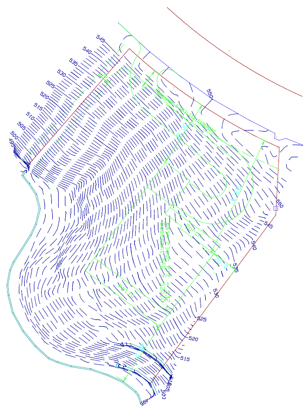
Much like any other type of survey, a topographic survey, or topo survey for short, is done to locate natural and man-made features on a particular parcel of land. This is sometimes called planimetric features or things you can see from a plan view as if you were hovering over the site. The topo survey is different in that the elevation of the surface of the land is surveyed and represented on the resulting map of the survey. The topo survey usually also includes any man-made underground features, like utility lines. The survey will also show above ground improvements like buildings, utility poles, retaining walls, etc.
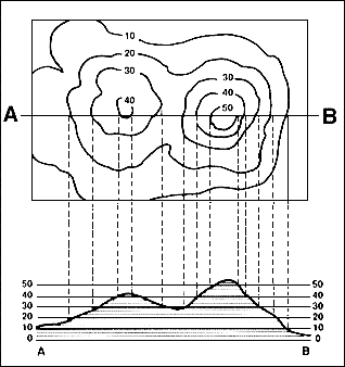 The elevation or differences in elevation on the surface is usually shown as contours. A contour line is a line that connects points of equal elevation. There is usually a contour interval set, say 1-foot for conventional survey. An aerial topo survey may have a contour interval of 2-foot to 5-foot typically. Again, these contours are a way to represent the relative elevations of the surface of the land. By industry standards, contour lines are accurate to within half the contour interval. So, a 1-foot contour line should be within a half foot (0.5’) of the actual elevation on the ground.
Some topo surveys also supplement the contours with spot elevations at certain important points. Depending on the purpose of the survey, these spot elevations may be accurate to a tenth of a foot (0.1’) or even a hundredth of a foot (0.01’) of the actual elevation.
Pacing is a fundamental aspect of land surveying that involves measuring distances by counting the number of steps taken by a person. This technique has been used for centuries and remains relevant today because it is a simple and cost-effective way to measure distances accurately. Pacing is particularly useful in remote areas or places where other measuring tools are not available.
The importance of pacing in land surveying cannot be overstated. It is a valuable tool that enables surveyors to obtain accurate measurements of distances, which is critical in establishing boundaries, determining property lines, and creating maps. Pacing is also a valuable tool for assessing terrain and determining the best routes for roads and other infrastructure projects.
One of the key benefits of pacing is its simplicity. Unlike other measuring tools that require specialized training or expensive equipment, pacing can be done by anyone who can walk. Surveyors can quickly and easily measure distances by counting their steps, making it an ideal method for small-scale surveys or for use in remote areas where other measuring tools may be difficult to access.
Another benefit of pacing is its accuracy. When done correctly, pacing can produce highly accurate measurements. Surveyors can achieve this by establishing a consistent stride length and pacing rhythm, which helps to ensure that each step covers the same distance. In addition, pacing can be combined with other measuring techniques, such as compass bearings and angles, to produce even more accurate results.
Pacing is also an essential tool for surveyors who work in challenging terrain. In areas where the terrain is steep or uneven, it can be difficult to use other measuring tools, such as lasers or total stations. In these situations, pacing can provide a quick and effective way to measure distances without the need for specialized equipment.
However, it is important to note that pacing does have its limitations. For example, it may not be the most accurate method of measuring distances over long distances or in areas with significant obstacles or changes in terrain. In addition, pacing requires a relatively flat and even surface, which may not always be available in certain environments.
In surveying, a prism is a corner cube or retroreflector, normally attached on a surveying pole, used as a target for distance measurement using, for example, a total station.
3D scanning is a technology used in Land Surveying for creating high-precision 3D models of real-world objects. 3D Scanners work like this: First, a 3D scanner takes multiple snapshots of an object. Next, the shots are then fused into a 3D model, an exact three-dimensional copy of the object that was scanned, which you can rotate and view from different angles on your computer.
Here are a list of Related Terms to 3D Scanning for you to learn (found in this post inside the 3D scanner Hub)
measurements and dimensions for use in many manufacturing processes.3D Laser Scanner – A 3D scanning device that uses a laser to reflect off
the part and triangulate with a camera lens, allowing the scanner to determine and create
XYZ coordinates. The scanner then uses these points to form a 3D digital model of the part.3D Modeling – 3D modeling refers to the creation of three-dimensional objects that are
defined mathematically and geometrically (i.e. a circle extruded to a certain value to create a cylinder
defined by its location, radius and length). 3D modeling can be aided by the use of scan data
(see Reverse Engineering).3D Scanner – 3D scanners come in many forms, but the purpose of every one of them is to
capture the shape, and sometimes color, of real-world physical objects or environments. This captured data
is typically stored as a list of xyz-coordinates in a point cloud file. 3D scanners can be categorized as
contact (CMM arms) or non-contact (white light, 3D laser scanners, or stereo-vision based). Some can even
capture internal features. “3D scanner” is sometimes mispelled as “3D scaner”.3D Scanning – 3D scanning is the fast and accurate process of using a 3D scanner to
capture and convert physical objects into digital 3D data.Accuracy – The accuracy is the closeness of a measurement to the actual feature.
The opposite of accuracy is uncertainty, which is an inverse perspective of the same value. See Uncertainty.Alignment – The process of aligning two objects in a common coordinate system. Commonly
refers to aligning scan data to reference objects in inspection applications.As-Built – An object’s real-world condition and appearance.As-Designed – How the object was originally designed, usually in a CAD environment.Auto Surfacing – Wrapping a patch-work quilt of freeform NURBS surfaces around scan data,
quickly and automatically generating surfaces.CAD – Computer Aided Design. CAD is a standard term defining a group of software that
aides in design. CAD software is what is used for 3D modeling and to create 2D drawings. It is typically used in
manufacturing or other engineering disciplines. For example: An engineer designs in SolidWorks, Pro-E, AutoCAD, CATIA,
or Unigraphics; all of which are CAD or CAE programs. Often confused with CAE.CAI – Computer Aided Inspection. CAI is a set of technologies that convert designs into
data used to run the inspection process.CAM – Computer Aided Manufacturing. CAM is a set of technologies that convert designs into
data used to run the manufacturing process.CAQ – Computer Aided Quality Assurance / Inspection / Control. See CAI.Class A – The most simple mathematical curve or surface that can describe a shape. Example:
A customer requests a “Class A” IGES surface when he needs a super smooth surface typically used in aerospace
or automotive applications.Color Map – A color plot visually representing deviations from actual to theoretical.
Example: A customer requests a colormap inspection when needing to compare an as-built object to its
as-designed CAD data.Computational Fluid Dynamics (CFD) – Computational fluid dynamics is the study and analysis
of fluid and gas flow in a system with the use of numerical methods algorithms. Computers are required to handle
the millions of calculations involved in CDF analysis with applications such as aerodynamic (wind tunnel) and
hydrodynamic testing. It is common to use a 3D scanner to capture object surface data for use in such tests.Datum – A certain feature such as a point, line, plane, cylinder, etc. that can be
used to establish the location or geometric relationship of another feature.Decimation – Decimation in general refers to reducing the number of samples in a
population. In 3D scanning, decimation usually refers to lowering the number of triangles on a surface
without distorting the detail or color. Decimation is used when there are a large number of unnecessary
triangles.Degrees of Freedom – Describes the numbers of directions of movement and refers to how
the position and orientation of an object is described relative to a coordinate system. In 3D scanning
it usually consists of three linear translations (X, Y, and Z) and three rotations about the three
axes (pitch, yaw, and roll).Deviation – As typically applied to 3D scanning, deviation refers to the difference
in the size and shape of a manufactured part versus its design specifications. Deviation is easily
discovered by quality inspection with the use of color maps and cross-sectional analysis found in CAI
applications.Digital Archiving – Storing data digitally. Objects can be scanned and processed
for digital archiving purposes, reducing the need to store physical parts in locations such as a warehouse.“Dumb” IGES – “Dumb” IGES is a term used to refer to any IGES, STEP or
other surface file format. Though technically a mathematical model, it is considered “dumb” because the data
contains no parametric history of the model; it is simply a surface that cannot be intelligently edited.
Ex: If a cylinder is modeled in 3D and exported in .IGES file format, the cylinder cannot be edited by
changing its radius or extrusion length.FEA – Finite Element Analysis. When a surface model is subjected to various tests
to determine or establish its integrity under specified conditions.FEM – Finite Element Model. The creation of a mathematical surface description of
an object resulting in a model ready for analysis.Fillet – A surface that connects two or more faces. This surface is usually an arc.Geometric Dimensioning & Tolerancing (GD&T) – Geometric Dimensioning and Tolerancing
is a standard used to define the nominal geometry of parts and assemblies, to define the allowable
variation in form and possibly size of individual features, and to define the allowable variation between features.Hybrid Surface Model – An IGES or STEP surface that usually combines auto-surfaced
features with typical 3D modeling operations. Hybrid models are “dumb” because the data contains no parametric history
of the model; it is simply a surface that cannot be intelligently edited. Such models have areas that are not ideally
mathematical in nature, and instead are composed of NURBS surface estimates of the scan data.IGES – Initial Graphics Exchange Specification / System is a standard mathematical
surface file, used for over 25 years in most CAD systems to mathematically represent physical data.
It is the most common format for exchanging CAD data between software programs. See also STEP.Inspection – See Quality Inspection.Laser Scanner or Laser-Line Scanner – See 3D Laser Scanner.Legacy Part – A part that is already created or existent in the customer environment.
As typically applied to 3D scanning, legacy parts usually do not have CAD data.Median Part Verification – When several of the same parts are scanned and the resulting
data is averaged and used to create one representative 3D model. Median part verification is used to minimize the effect
of manufacturing defects on the resultant model.Merge – Combining two or more scan data sets into one larger data set.Mesh – See Poly-mesh.Noise – Noise is the existence of extraneous recorded data within a point cloud. It
can be caused by an object obstructing the sensor or ambient light and reflections into the sensor
during the data capture process.NURBS – Non Uniform Rational Basis, or Bézier Spline. It is a mathematical model
commonly used for generating and representing curves and surfaces that cannot be decimated in a
uniform manner. It can also be a surface created by two or more b-splines. First developed mid-century
but didn’t arrive on the desktop until 1989.Organized STL – Mesh data consisting of point cloud data with mathematical point
spacing based on surface data. An organized STL of a cube would consist of 8 points (1 for each corner).Parametric Model – A data set that retains the history of how it was designed, so
that modifications update all downstream features. Exchange of such models is supported by IGES.
SolidWorks is a software program that is popular for creating and modifying parametric models.Performance Surfaces – Surfaces that are affected by certain aerodynamic and
hydrodynamic forces. The shape of these surfaces is usually key to the performance of the object.Photogrammetry – The process of taking precise measurements by using digital
pictures and coded targets. For 3D scanning purposes, the coded targets and reference markers in
the picture frame serve as anchor points where scans can be aligned to. Photogrammetry ensures
extremely accurate scan data. Also see Videogrammetry.Precision – The repeatability of performing a measurement.Point Cloud – A point cloud is the computer visualization of the XYZ coordinates
that describe a physical object or environment. Each point represents an actual point on the object
or in the environment, and collectively describes its shape and measurements. Points can be captured
individually, such as with a CMM, or thousands at a time, such as with a 3D laser scanner that
captures multiple point sets from different perspectives that can be merged into a cloud. Point
clouds are typically represented by an unorganized STL file. Synonomous with raw scan data.Poly-mesh – A polygonal model that is used in 3D computer graphics. A mesh is a
visualization of point cloud data that basically connects the dots to form triangles. See also STL.Quality Inspection – The process of evaluating a physical part and comparing it to
the design specifications that are described in the object’s CAD file. Inspection is an “as built”
vs “as designed” comparison. See also Deviation.Rapid Surfacing – See Auto Surfacing.Reference Markers – Adhesive backed retro-reflective dots used in 3D scanning
applications to create reference points and help align pieces of scan data. Some scanners, such as
the Handyscan 3D, use reference markers to position themselves in space, eliminating the need for
attachment to a CMM arm or a fixed focal length.Registration – The process of aligning two data sets together based on known
coordinates in each. Registration enables the alignment and integration of two of more point cloud
data sets to complete larger models that must be captured in multiple scans.Rendering – A graphical representation of a computer model. It is often used to
describe the visual output of CAD and Modeling software. By rendering a computer model, you can often
add characteristics and effects to its surfaces and features.Resolution – The spacing of points in a grid. The higher the resolution, the more
data that will be captured. Likewise, the lower the resolution, the “flatter” the detail.Reverse Engineering – Reverse engineering broadly refers to analyzing and dissecting
something with the goal of recreating it. In 3D scanning, reverse engineering typically means the
process of measuring an object using a 3D scanner and then creating CAD data that reflects its original
design intent. This can also be done by using rulers, calipers, or a CMM. Reverse engineering is sometimes
referred to as Reverse Modeling.Reverse Modeling – See Reverse Engineering.Scan – Measuring the part, capturing data, and transferring the measured points to
the computer. It also refers to the computer file that is based on the physical part, i.e., xyz coordinates
that represent physical measurements taken by the scanner.Shell – A particular operation for CAD. In 3D scanning, involves the creation of an
offset surface from the original surface in order to create thickness.Shrink Wrap Surface Model – Refers to the way in which 3D scanning software like Geomagic,
RapidForm, and Paraform fit mathematical IGES surfaces to a “physical” scan. Similar to how plastic shrinkwrap
“shrinks” down onto a part being “wrapped”.Stereo Vision – A method of capturing three dimensional data based only on cameras. An algorithm
of stereo vision involves receiving inputs from two or more different cameras oriented at different angles and
analyzing the differences between the images to obtain 3D information. This 3D information is easily read as a
3D point cloud.STEP – Standard for the Exchange of Product Model Data is a comprehensive ISO data standard
(ISO 10303) for the exchange of object descriptions between systems. STEP is a file format that is usually
interchangeable with IGES.STL – Standard Tessellation Language. STL is a special internationally recognized file format
that stores XYZ coordinate measurements and their normals. Gives the added functionality beyond XYZ coordinates
enabling visualization of a part’s “front” and “back.” STL is the standard file format for rapid prototyping,
and is used in reverse engineering. See Organized STL and Unorganized STL.Surface – Refers to the part being scanned or to the computer file from the scanner. It typically
means a computer file in IGES format. See also IGES.Surfacing – The process of defining or creating a surface on a CAD model. Typically refers to
converting a polygonal representation of an object to a NURBS or other mathematical representation. It is the
process of converting physical based 3D data to mathematical based 3D data. See also Auto Surfacing and Reverse
Engineering.Talc – Talc powder is typically applied to translucent, reflective, or black/near-black
objects during the 3D laser scanning process in order to improve the ability of the laser scanner to
capture data. Talc powder is predominantly white and is usually applied with a pen or an aerosol spray.
Talc can easily be wiped off and cleaned, and generally will not damage an object.Targets – See Reference Markers.Tessellation – Generally refers to filling a surface plane or surface with shapes that
create no gaps or holes. In 3D scanning, this concept applies to wrapping a mesh around a CAD body. A jigsaw
puzzle is a great real world example of a collection of tessellated shapes.Time of Flight – 3D laser scanners that calculate measurements based on the time it
takes for the laser beam to detect a surface and report back.Touch Probe – A Coordinate Measuring Machine (CMM) that requires physical contact
with the part to measure it.Triangulation – Using trigonometric functions to calculate measurements, used in
certain types of 3D laser scanners to determine point locations based on transmission and reflection
positions of the laser beam. In 3D modeling, triangulation also refers to the generation of triangles
out of point cloud data in creating 3D surfaces.Uncertainty – The uncertainty is the quantity of how much a measurement is
unknown compared to the actual feature. Uncertainty is the inverse perspective of accuracy, which is defined
as the closeness of a measurement to the actual feature. The uncertainty essentially describes how much of
a measurement is uncertain. See Accuracy.Unorganized STL – Mesh data based on point cloud data taken from a scan. Point
spacing is based off the number and resolution of scans and not dependant on the shape or features
of the object being scanned.Videogrammetry – The process of taking precise measurements by using video images
taken from two or more video cameras taken at different angles.Watertight – Refers to mesh or surface data that does not contain any holes much
like a real object’s ability to hold water.White Light Scanning (Interferometry) –
Optical non-contact method for measuring physical parts. White light scanners obtain measurements of
an object by determining changes in the fringe and distortion of a pattern of white light projected on
an object.
Land surveyors have always produced drawings that show the property as if you were looking at it from above the earth. This shows property lines, outline of buildings, fences, encroachments, and distances and directions of the property lines. With the addition of aerial images “orthorectified” to the survey drawing we can communicate another “thousand words” to those viewing the drawing. Orthorectified means the lines shown on the map match up with the photo. Normally when you look at an aerial map with property lines shown, you’ll notice that the lines don’t match. In fact, sometimes Google will show the tax maps on the map, but NEVER show the aerial images along with that. They just won’t match from the aerial views that they provide. We can produce ortho photos of your property along with the surveying lines and labeling.
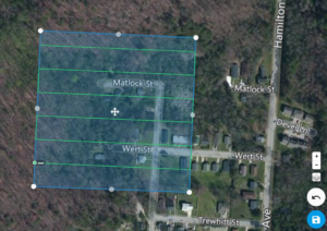 A surveyor CAN match the precisely run survey with the aerial photography by using aerial control points to “control” the production of the image. This process is called photogrammetry, the science of making measurements from photographs. Photogrammetry has been practiced since the mid-1800’s. Leonardo da Vinci developed the concepts that were used for obtaining perspective and projective geometry. The first aerial photography was captured using kites and balloons. The first photography to be used for aerial mapping was captured in 1908, only 5 short years after the invention of the Airplane by the Wright brothers.
Using aerial surveying can be a real time saver for a lot of surveying jobs and it enables us to get a very complete set of data, something that a survey crew in the field would have a hard time doing in a timely fashion. Safety is another of the benefits of aerial surveying using drones. Instead of sending our surveyors into a busy street or a situation with steep grades or equipment that could potentially be hazardous we are able to avoid this by remotely collecting this data with the drone.
Using Drones became an option for our business when we realized we needed both faster turnaround times and more detailed modeling of site topography for many projects. Drone aerial mapping offers quicker, more complete mapping than ground survey methods in many cases, so that problem areas can be identified and addressed. Of course, tree cover is still a problem during the leafy season but winter time is a good time to pick up these images.
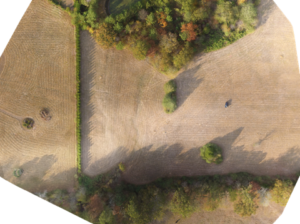
It is also possible for us to generate our own current, high-resolution aerial imagery for areas where none is available. We are also able to use the drones to produce quality 3d surface models (DTM surfaces) with very dense point sampling. Doing this before drones required a plane or helicopter to fly over the site. This was a VERY expensive task. Now with the drone we have the images back in the office to do the mapping work in less than a day and with significant cost savings.
We can deliver the final aerial survey drawing product in picture formats (TIFF, PNG, JPG, etc,) and the normal surveying industry formats of DWG, DXF, and LAS files.
Let us put our drone aerial mapping and drone surveying knowledge, skill, and experience to work for you! Call us at (423) 702-6505 today.
Magnetic Declination is the bearing on a given date (reckoned east or west from the north branch of the celestial meridian plane) of magnetic north as determined by the positive pole of a freely suspended magnetic needle which is subject to no transient artificial disturbance.
An example provided by Compass Dude
Here is a map of the angles of declination for the U.S. as of 2010:
Notice the black line with 0� on it running down the Mississippi river? Along this particular line, both the geographic and magnetic north poles are in alignment so there is no declination. If you move East of this line, the magnetic north pole will pull your compass needle further and further to the West of geographic north - the angle of compass declination is West Declination. Moving west of the Mississippi river will pull your compass needle further and further to the East.
A few Videos about Magnetic Declination:
Related Term: Magnetic Variation
Regular or erratic change in magnetic declination. Not interchangeable with declination but old field notes use Var. as the declination of the compass.
Normally the two sets of corners along a standard parallel; the standard township, section, and quarter-section corners placed at regular intervals of measurement; additionally, the closing corners established on the line at the points of intersection of the guide meridians, range and section lines of the surveys brought in from the south. In other cases, not fully in conformity with the rectangular plan, two corners, each common to two townships only, instead of one corner of the four townships. Similarly, two corners, each common to two sections; and two quarter-section corners, each referring to one section only.
The term Double Corner is sometimes used incorrectly to denote two lines established on the ground although the field-note record indicates only one line, thus creating a hiatus or overlap.
An affidavit of merit is a requirement in some jurisdictions, primarily in medical malpractice claims, to have an expert file an affidavit stating the claim has merit. It is a measure enacted to deter frivolous lawsuits. When a plaintiff in a medical liability lawsuit does not file an affidavit of merit with the complaint, the case may be dismissed. Below is a detailed explanation of Affidavit of Merit for State of Texas
Affidavits of merit, sometimes referred to as a certificate of merit, in the most general of terms, are affidavits signed by an expert in the field, attesting to the merit or merits of a claim. Depending on the state, affidavits of merit may be required in medical malpractice claims, legal malpractice claims, and other claims involving some sort of professional negligence. This may include cases against architects, accountants, engineers, land surveyors, real estate agents, as well as design professionals.
Affidavits of merit are a product of tort reform efforts. It is believed that requiring a party to file an affidavit of merit, either contemporaneous to or shortly after filing a lawsuit, accomplishes several goals, including:
Reducing the number of suits being filedReducing the amount of money put towards settling claims of questionable valueLimiting the types and amounts of liability insurance professionals must carryLimiting the number and types of decisions made not out of professional judgment but rather fear of a potential lawsuitBecause, by and large, affidavits of merit require a professional in the field to opine under oath about a failure to meet a minimum standard of care, it is believed frivolous claims will be reduced, if not eliminated. Affidavits of merit also necessarily limit the extent of claims made to that which can reasonably be proven based on the facts and circumstances of a given case.
When a land surveyor locates and establishes points between two survey stations, that act is called ranging. There are two conventional methods of ranging: the direct method and the indirect method.
Direct Ranging Method
This is applicable to situations where the ends of the survey stations are inter-visible. Meaning, you can see point X from point Y and vice versa.
Indirect Ranging Method
This one is for survey stations that aren’t inter-visible. Ranging rods are set up between the two points or survey stations, thereby guiding the surveyor or any viewer on where the straight boundary line lies.
Land surveyors typically use range poles or ranging rods to mark points and survey lines.